Historical maps contain a vast amount of intelligence about the urban environment, and are essential in understanding the modern city. They highlight safety risks from historic contamination or underground infrastructure. They can also give a deeper understanding of the social and economic anatomy of a city, and the logic behind each stage of development.
Last year, we created a colour-enhanced version of Glasgow's 1930s Ordnance Survey map, which can be switched to the present-day OS map, so you can explore the city at its peak population of over a million people, before the motorways carved it apart. You can explore the map here: www.glasgowbeforethemotorway.com
The map captures Glasgow at an interesting moment - the modern city is recognisable (Central Station, the city centre gridiron, Ibrox and Celtic parks) but huge swathes that would soon disappear are still intact.
A few hidden stories from the map
A cinema and an anti-apartheid protest
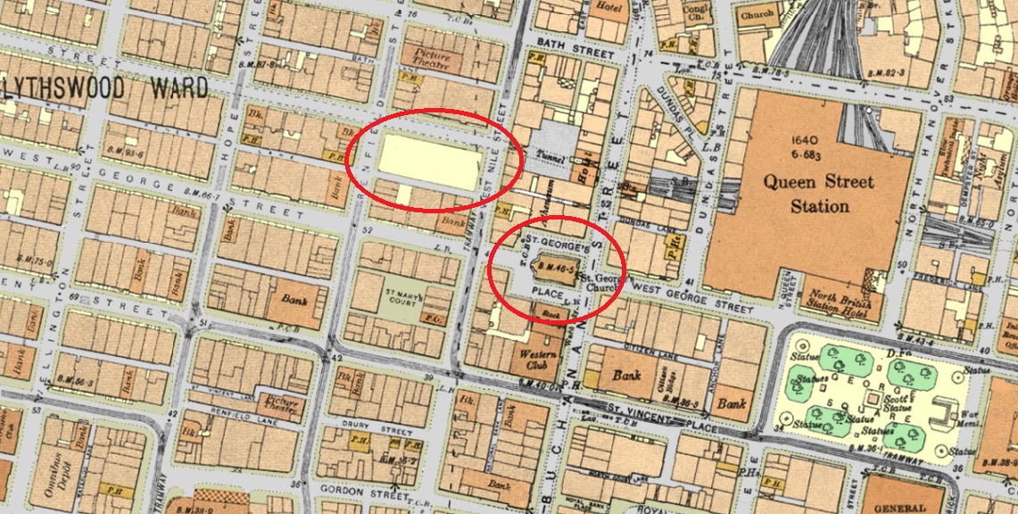
You can see there is an urban block between Renfield Street and West Nile Street where the northern half is a blank open space. This was to be the site of the Renfield Street Odeon, built a couple of years after this map was drawn, a new cinema that became a famous art-deco landmark.
Also, just to the south-east, there is an interesting story behind St George's Place. It was renamed 'Nelson Mandela Place' in 1986, forcing the South African consulate located there to use the name of their most famous political prisoner as their official address.
Phoenix park
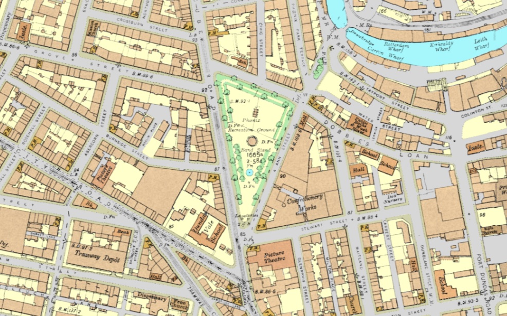
Just north of Cowcaddens subway station there used to be a long triangular park which climbed up the hill towards the canal. It originally housed a bandstand and a large fountain, later re-landscaped with modern gardens and a children's playground, before it was demolished to make way for the M8.
St Enoch Station
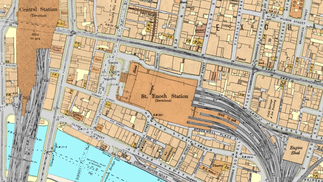
Today, this site is known for the St Enoch Shopping Centre, but from 1876 to 1966 it was the site of St Enoch Station, demolished in 1977.
A railway for carrying boats in tanks of water
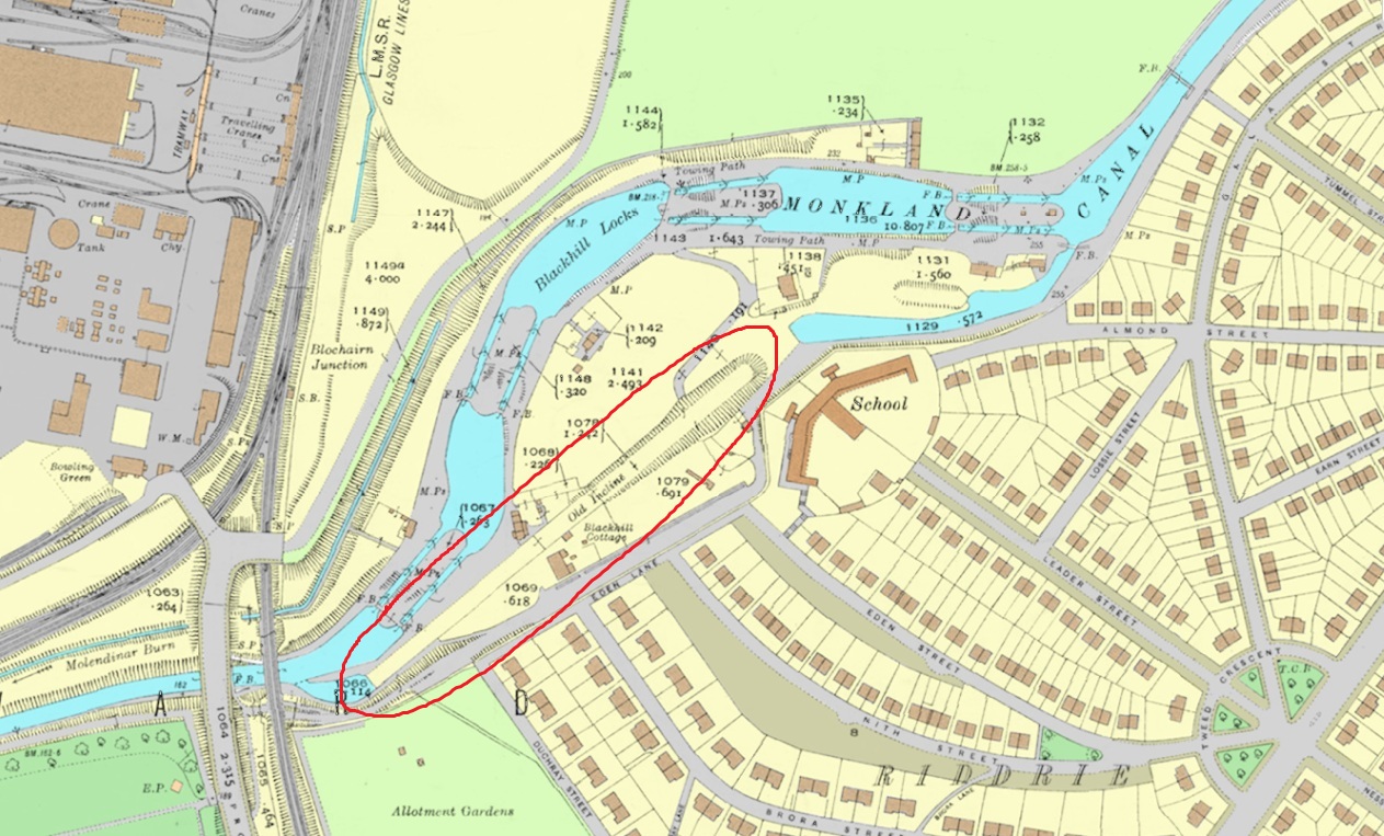
East of the city centre, the new M8 motorway was built roughly along the route of the Monkland Canal which has now disappeared. The 1930s map is interesting as it still shows the 'Old Incline' which was built as an alternative route to the system of canal locks climbing up the hill, just north of the new suburb of Riddrie.
It was a steam-powered rail system which could carry boats in water tanks on rails up and down the hill, partly to ease congestion in the locks, but also to save water. The incline closed in the 1880s, but the locks remained open until the 1950s.
City centre docks
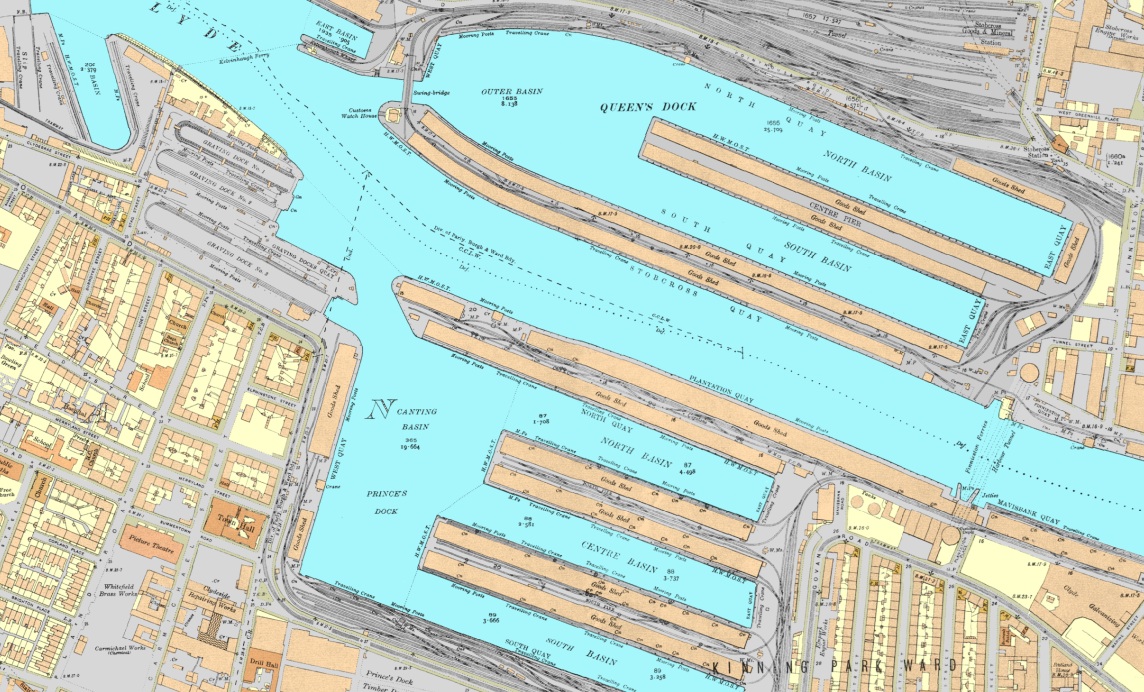
These two large dock complexes in the city centre have been largely filled in. The north side is now the site of the SEC event centre. The basins to the south were mostly filled in and were the site of the 1988 Glasgow Garden Festival, and later the Glasgow Science Centre and office buildings.
Why does this matter?
I don't want to romanticize the city at this point in history. The 1930s city had very serious problems of overcrowding, pollution and economic depression. But from an urban planning perspective, it got a lot of fundamentals right that we're now trying to recreate - density, walkability, mixed use, and excellent public transport (the Subway had opened 37 years before the time of the map).
The civic infrastructure and built form of the time also gave urban neighbourhoods a clear identity, well served by democratic public spaces such as parks and libraries. Today, while many parks and libraries survive, urban focal points such as Anderston Cross, Charing Cross and St George's Cross have been destroyed as meaningful centres by redevelopment and highways engineering.
Understanding and working with the historic built heritage of a city is complex and requires a different skill set from many developments, but it can also create much greater economic, social and environmental value in the long term.
About this project
At Charlbury Technology, we specialize in managing the delivery of digital PropTech and real estate development products, from rapid initial prototypes to full-scale projects.
We built this as an open tool for anyone interested in Glasgow's built history, and to showcase the type of geospatial analysis we are interested in enabling.
Contact us for an initial discussion about how digital technology can help provide you with more information, understand risks, and make better decisions. What would you like to visualize? Site analysis, location intelligence for investment decisions, or another custom mapping and urban analysis project?
Contact us